The EEOICPA was passed in 2000. It provides compensation to workers who became ill as a result of their employment manufacturing nuclear weapons in the USA, as well as their spouses, children, and grandchildren. Project Shoal Nuclear Explosion Site EEOICPA coverage is available for qualified former Workers and their families.
Are you eligible for compensation? If you or a family member worked at this or another DOE facility and became ill, you may be entitled to compensation of up to $400K plus medical benefits. Call EEOICPA Counsel Hugh Stephens at 1-855-548-4494 or fill out our free claim evaluation, We can help even if you’ve already filed, even if your claim was denied!
Here, we have compiled publicly available information and documentation about the facilities covered by the Act to clarify how their activities relate to the Energy Employees Occupational Illness Compensation Program Act.
Project Shoal Nuclear Explosion Site
State: Nevada
Location: Fallon
Time Period: 1962-1964
Facility Type: Department of Energy
Facility Description: Project Shoal was an underground nuclear test explosion which was part of a program designed to improve the United States’ ability to detect, identify, and locate underground nuclear explosions. The Shoal test was conducted to determine the behavior and characteristics of seismic signals generated by nuclear explosions in specific geological formations and to differentiate them from seismic signals generated by earthquakes.
Construction for this shot began in late 1962. The shot was fired on October 10, 1963. Post-shot drilling began October 28, 1963; drilling and sampling of one vertical bore hole was completed on December 20, 1963. Reopening and sampling the USBM#1 bore hole was completed on January 15, 1964. Site deactivation of the Shoal Project began on October 28, 1963 and rollup was completed by January 31, 1964.
*On October 26, 1963, the Department of Defense (DoD) and the Atomic Energy Commission (AEC) (now known as the U. S. Department of Energy (DOE)) detonated a nuclear device with a total yield of 12 kilotons at a depth of 1,204 feet below ground surface in the solid granite of the Sand Springs Range southeast of Fallon, Nevada.
Radiological contamination of groundwater resulted from the test. Today, scientists and engineers, contracted by DOE, are working to identify the risks where radiological contamination exists in groundwater, predict the movement of the contaminated groundwater, and define the extent of migration of the radionuclides released during testing.
*Source
Listing:
Project Shoal Nuclear Explosion Site is listed as a Department of Energy (DOE) site under the EEOICPA.
Compensation:
As of 05/10/2015, the total compensation paid under Parts B and E of the EEOICPA, including medical compensation, for workers suffering from the effects of having worked at the Project Shoal Nuclear Explosion Site is $655,889.
Project Shoal Nuclear Explosion Site Workers:
If you or your parent worked at this or any other DOE or AWE facility and became ill, you may be entitled to compensation of up to $400K plus medical benefits from the US Department of Labor. Call EEOICPA Counsel Hugh Stephens at 1-855-EEOICPA (336-4272) or fill out the form to the right, whether or not you have already filed a claim and even if your claim has been accepted or denied.
We can help with all OWCP (Federal Workers Compensation) claims, impairments, wage loss and health care. 2495 Main Street, Suite 442, Buffalo, NY 14214.
“Project Shoal” Nuclear Test newsreel Footage:
Site Description and History:
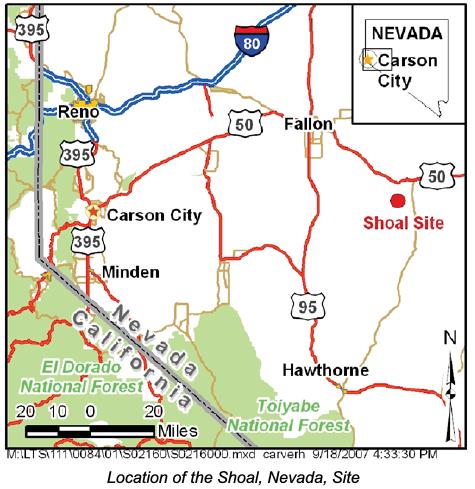
The Shoal Site is situated on 2,560 acres of withdrawn federal lands located within the north-central portion of the Sand Springs Range in Churchill County, Nevada. The town of Fallon is the largest populated area in the region and is about 30 miles northwest of the site. The region around the Shoal Site is sparsely populated; military installations, recreation, ranching, and mining provide the dominant commercial interests.
The Project Shoal underground nuclear test was part of the Vela Uniform program sponsored jointly by the U.S Department of Defense and U.S. Atomic Energy Commission (AEC), a predecessor agency of the U.S. Department of Energy (DOE). Vela Uniform was a research and development program directed toward locating, detecting, and identifying underground detona- tions. The objective of Project Shoal was to detonate a nuclear device underground in an active seismic area to improve the United States’ ability to detect, identify, and locate underground nuclear detonations.
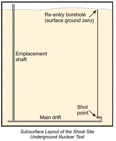
The Project Shoal test was performed on October 26, 1963. The test consisted of detonating a 12-kiloton nuclear device in granitic rock at a depth of approximately 1,211 feet below ground surface. Emplacement of the device was accomplished through a shaft located approximately 1,000 feet west of surface ground zero (SGZ). The shaft was mined to a depth of approximately 1,315 feet below ground surface. At that depth, a drift (a nearly horizontal tunnel) was mined approximately 300 feet west and 1,050 feet east, ending in a 30-foot vertical “buttonhook” where the nuclear device was emplaced. Re-entry drilling directly over the detonation cavity indicated that the Shoal device detonated as predicted, and a rubble chimney about 171 feet in diameter and about 356 feet high was formed above the shot point from the explosion. No radiation escaped to the surface during the underground nuclear test, and no further underground nuclear testing was conducted at the site.
Groundwater is present beneath the site at depths ranging from approximately 970 to 1,090 feet below ground surface. Groundwater moves primarily through fractures in the granite. Groundwater recharge occurs by infiltration of precipitation in the Sand Springs Range, and regional discharge occurs in the valleys.
Surface Conditions :
Surface contamination resulted from the re-entry drilling activities at the Shoal Site. Contamination at the surface was identified as Corrective Action Unit (CAU) 416. Surface restoration was completed in 1998. The Nevada Division of Environmental Protection approved the Closue Report on February 13, 1998, stating that no post-closure monitoring is required and no land use restrictions apply at CAU 416.
Subsurface Conditions :
Subsurface contamination resulted from the underground nuclear test at the Shoal Site and is identified as CAU 447. This CAU consists of the test cavity and the emplacement shaft. Because there is no known technology to remediate the remaining subsurface radioactivity, a groundwater flow and transport model was developed to estimate a contaminant boundary, or restricted region, surrounding the nuclear detonation. The contaminant boundary represents the maximum extent that groundwater contaminated with test-related radionuclides is estimated to migrate in 1,000 years. Through agreement with the Nevada Division of Environmental Protection, the contaminant boundary serves as the compliance boundary at the Shoal Site.
The original corrective action strategy for CAU 447 required the installation of monitor wells for validation of the groundwater flow and transport model and monitoring. The model did not validate and a new corrective action strategy is being developed for the site. This corrective action strategy will be negotiated with the Nevada Division of Environmental Protection.
Long-Term Hydrologic Monitoring Program :
The U.S. Environmental Protection Agency has conducted a Long-Term Hydrologic Monitoring Program (LTHMP) at and near the Shoal Site since 1972. The monitoring program consisted of collecting and analyzing groundwater samples for tritium and gamma- emitting radionuclides. The LTHMP sampling network currently consists of 11 on-site monitor wells and 6 off-site sample locations (three wells, two windmills, and one spring). Since its inception, analytical data obtained from samples collected at the offsite locations have indicated no detections of radionuclides from the underground nuclear test using conventional analytical methods. In support of these data, a more refined monitoring network is being developed for the Shoal site that will focus the monitoring to onsite wells.
Land Use :
The Shoal Site was withdrawn in September 1962 from the Bureau of Land Management for all forms of appropriation including mining and mineral exploration and was reserved to the AEC for the experiment. In Title XXX of the Defense Authorization Act of 2000, the surface of the Shoal Site along with the surrounding area was reserved to the U.S. Navy for testing and training for tactical maneuvering and air support. Under this same act, DOE retained responsibility and liability for subsurface interests. The region around the Shoal Site is sparsely populated; military installations, recreation, ranching, and mining are the dominant activities in the region. No residences or habitable structures are on the site.
Institutional Controls :
No institutional controls are required for the surface of the Shoal Site. A notice of restrictions associated with the subsurface is provided on a monument located near a borehole directly over the test cavity, now known as surface ground zero. The monument defines restrictions for excavation, drilling, and removal of material between elevations of 5,050 feet and 3,530 feet above mean sea level and extending to a horizontal distance of 3,300 feet in any direction from surface ground zero. The 1999 Navy land withdrawal also include restrictions to prevent drilling on the property, a requirement of notification of drilling on adjacent Bureau of Land Management land, and restricted access postings to discourage incidental intrusion. The subsurface will require long-term surveillance and monitoring because of radiological contamination in the test cavity.
*Source


